Maharashtra Government Notifies Mumbai 3.0: Check Full Map and GR; Is it Worth Investing?

The Mumbai Metropolitan Region (MMR) is on the brink of its most significant urban expansion since the creation of Navi Mumbai in the 1970s. Popularly dubbed “Mumbai 3.0” or “Third Mumbai,” this ambitious project is officially named the Karnala-Sai-Chirner (KSC) New Town.

Envisioned as a high-tech, self-sustaining economic engine, KSC New Town is designed to capitalize on massive infrastructure projects like the Atal Setu (MTHL) and the Navi Mumbai International Airport (NMIA). For residents, it promises relief from Mumbai’s congestion; for investors, it represents a “once-in-a-generation” opportunity.
1. Legal Identity and Planning Authority
While the media uses the catchy “Mumbai 3.0” moniker, the legal framework is grounded in the Maharashtra Regional and Town Planning (MRTP) Act, 1966.
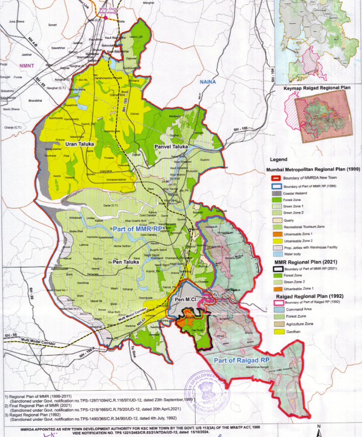
According to the official notification issued by the Urban Development Department (UDD), the project is formally recognized as the Karnala-Sai-Chirner (KSC) New Town. On October 15, 2024, the Government of Maharashtra appointed the Mumbai Metropolitan Region Development Authority (MMRDA) as the New Town Development Authority (NTDA) for this region. This shift is critical as it grants MMRDA—traditionally an infrastructure body—the executive powers to plan, zone, and acquire land, effectively replacing previous jurisdictions for the designated 124 villages.
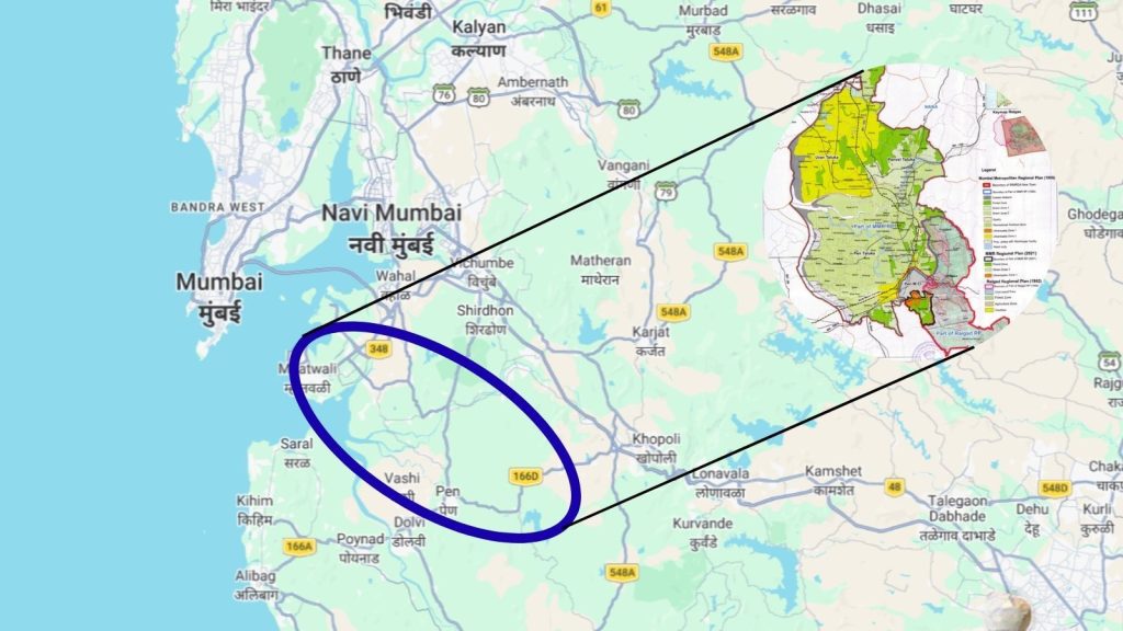
2. Location and Geographical Scope
KSC New Town is not merely a suburb; it is a massive urban sprawl covering approximately 323.44 square kilometers.
The “influence zone” spans three key tehsils in the Raigad District:
- Uran: The coastal gateway, home to the JNPT port and the landing point of the Atal Setu.
- Panvel: The commercial anchor and transit hub.
- Pen: The emerging industrial and logistics corridor.
The project encompasses 124 villages, including strategic nodes like Chirner, Sai, Dighode, and Vindhane. Geographically, it sits in a 25-kilometer development radius around the upcoming Navi Mumbai International Airport, making it the primary residential and commercial support system for the aviation hub.
3. Land Acquisition: The 2026 Policy Framework
The most critical milestone for Mumbai 3.0 occurred on Tuesday, March 17, 2026, when the state government issued a comprehensive Government Resolution (GR) regarding land acquisition.
According to the MMRDA’s Land Acquisition and Allocation Policy, the government is moving away from purely compulsory acquisition in favor of a “partnership” model.
The 22.5% Compensation Model
Following the successful CIDCO model used in Navi Mumbai, the GR offers consenting landowners 22.5% of the developed land back in exchange for their raw plots. These returned plots will be “infrastructure-ready,” meaning they come with pre-installed roads, electricity, water, and sewerage.
Alternative Compensation
For those not opting for land pooling, the GR provides three other avenues:
- Direct Cash: Compensation as per the LARR Act, 2013 at prevailing market rates.
- FSI and TDR: Granting Floor Space Index or Transferable Development Rights for use elsewhere.
- Small Plot Exception: Owners with less than 40 square meters receive mandatory cash compensation.
4. Connectivity: The Pillars of Growth
Mumbai 3.0 is an infrastructure-led city. Its viability rests on four major pillars:
- Atal Setu (MTHL): Now fully operational, this 21.8 km sea bridge has slashed travel time from South Mumbai to the KSC gateway (Chirle) to just 20 minutes.
- Navi Mumbai International Airport (NMIA): Scheduled for its first phase launch in 2025-2026, the airport is expected to handle 20 million passengers initially, driving massive demand for “Aerocity” style commercial spaces.
- Virar-Alibaug Multimodal Corridor: This 126 km mega-highway will connect the northern fringes of the MMR to the southern Raigad coast, with KSC New Town sitting right at its center.
- Metro Line 8 (Gold Line): A proposed high-speed metro connecting the existing Chhatrapati Shivaji Maharaj International Airport (CSMIA) directly to NMIA, ensuring seamless transit between the two cities.
5. Specialized Economic Zones
Unlike traditional residential townships, KSC New Town is being zoned for specific global industries. According to the MMRDA’s 2026-27 Budget, which allocated ₹4,000 crore specifically for Mumbai 3.0, the city will feature:
- Edu-City: Space for five top-tier global universities to establish Indian campuses.
- Medi-City: A high-tech healthcare cluster focusing on medical research and super-specialty hospitals.
- Data Center Hub: Projected to host nearly 65% of India’s data storage capacity, leveraging the stable power and connectivity of the Raigad coast.
6. Investment Outlook: Should You Buy?
For investors, the question isn’t “if” but “where.” Current land prices in the Uran and Pen tehsils range from ₹1,500 to ₹6,000 per sq. ft., while established nodes like Panvel and Ulwe range from ₹8,000 to ₹18,000 per sq. ft.
The Investment Case
- Early Entry: With the Master Plan target completion set for August 2026, current buyers are entering at “pre-vision” prices.
- ROI Potential: Real estate analysts predict a 2.5x to 4x appreciation by 2030, mirroring the boom seen in Gurgaon or Navi Mumbai’s early days.
- Global Backing: According to recent market reports, global investment firms like Blackstone have signaled multi-billion dollar interests in the region’s logistics and infrastructure sectors.
The Risks
- Timeline: Urban development is a marathon. Substantial completion of Phase 1 is not expected until the early 2030s.
- Legal Hurdles: As with any large-scale acquisition, disputes over village boundaries and forest land (which is excluded from the GR) could cause localized delays.
7. Conclusion: A New Urban Paradigm
Mumbai 3.0 (KSC New Town) represents more than just a real estate play; it is a structural shift in India’s economic geography. By moving the “center of gravity” across the harbor, the Maharashtra government is creating a modern, smart-city alternative to the aging infrastructure of the main island.
For the savvy investor or homebuyer, the March 2026 GR is the starting whistle. The transition from “agricultural land” to “global economic hub” has officially begun.
Disclaimer: All the information provided, including maps, in this article are available in public domain. The information and maps provide approximate details and are not claimed to be accurate. It is highly advisable to consult official sources before taking any decision based on the information provided above.