Heavy Rainfall Alert for Maharashtra Between May 20–25: IMD Warns of Flooding, Crop Damage, and Travel Disruptions
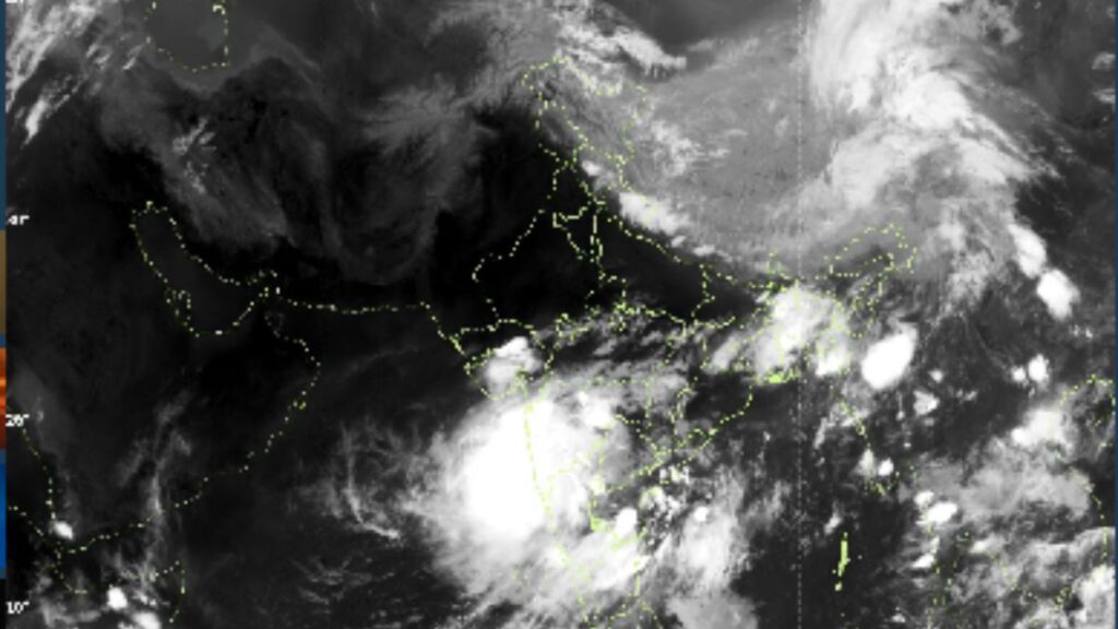

Pune, May 20, 2025 — The India Meteorological Department (IMD) has issued an important alert forecasting a significant increase in rainfall activity across several parts of Maharashtra from May 20 to May 25, 2025. The change in weather is due to developing cyclonic systems over the Arabian Sea and South Interior Karnataka.
Cyclonic Systems Triggering Rainfall Surge
According to IMD, an upper air cyclonic circulation is expected to form over the east-central Arabian Sea off the Karnataka coast around May 21, leading to the formation of a low-pressure area over the same region by May 22. This system is likely to move northwards and intensify, enhancing rainfall across the state.
Additionally, another cyclonic circulation already lies over South Interior Karnataka and surrounding regions, influencing the weather conditions and tilting southwestwards with height in the troposphere. These systems will contribute to intensified rainfall across Maharashtra during the forecasted period.
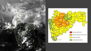
Rainfall Forecast for Maharashtra (May 20–25)
- Konkan and Madhya Maharashtra (Ghat areas): Fairly widespread to widespread rainfall with heavy to very heavy rainfall at isolated places is likely. South Konkan may experience extremely heavy rainfall on May 20.
- Madhya Maharashtra and Marathwada: Isolated to scattered light to moderate rainfall, with thunderstorms, lightning, and gusty winds of 50-60 kmph expected between May 20 and May 23.
Monsoon Progress Update
The northern limit of the southwest monsoon currently stretches across a significant belt from the Arabian Sea to Northeast India. IMD reports that conditions are becoming favourable for monsoon onset over Kerala within 4–5 days. This is also expected to support the advance of the monsoon over parts of South Arabian Sea, Maldives, Lakshadweep, Kerala, Tamil Nadu, and central and northeastern parts of the Bay of Bengal.
Expected Impact on Ground
The forecasted weather may lead to multiple adverse effects across the region:
- Localized flooding/inundation in low-lying and urban areas
- Flash floods and waterlogging on roads and bridges
- Uprooting of weak trees, collapse of dilapidated structures
- Landslides, mudslides, and rock falls in hilly terrains
- Damage to standing crops, plantations, and horticulture
- Power and municipal service disruptions
- Coastal squally winds and rough sea conditions
- Risk of cloud-to-ground lightning strikes
Travel disruptions across road, rail, air, and ferry routes are anticipated.
Safety Advisories for Public
Residents and travellers are urged to exercise extreme caution:
- Avoid flood-prone and waterlogged areas
- Refrain from staying in weak or vulnerable structures
- Stay indoors during thunderstorms; unplug electronic devices
- Don’t take shelter under tall trees during lightning activity
- Stay away from water bodies and objects that conduct electricity
- Follow official traffic and weather advisories regularly
IMD stresses that these warnings are based on the latest observations and predictive models. Citizens are encouraged to stay updated via IMD’s official platforms.
For real-time weather alerts and forecasts, visit:
🔗 IMD HQ
🔗 IMD Mumbai
🔗 IMD Nagpur